|
Mattydale Army Air Base |
|
Abandoned Runways Remain |

|
Mattydale Army Air Base |
|
In early 1942 the U.S. Government purchased the farms in the northeast corner of Mattydale. The purchase included land in the towns of Salina, DeWitt and Cicero. The area was relatively flat and having been farmland there were only some farm buildings that needed to be cleared where needed. An air base was built for the purposes of training and aircraft maintenance. In the haste to complete the air base many buildings were left untouched if they were not in the path of the construction. Between the runways, abandoned crops continued to grow every year.
After the war the Army Air Base became Hancock Airport and was expanded in the 1960s to become Hancock International Airport. The evolution of the commercial airport was not a hasty process, but like the original air base construction, remnants of the previous occupant were left untouched. Many of the concrete pads, used for storing planes and the auxiliary runways connecting the pads around the old Army Air Base, are still visible today. The view below shows the southwest corner of the airport.
A little speculation might provide the reasoning behind the scattering of the pads around the base. Since this was an air base far removed from any conflict, there was little or no fear that the planes might become the target of an aerial attack. Sabotage was of greater concern and with the planes concentrated close together a single bomb might take out many planes despite the seemingly easier task of guarding them. By spreading out the pads over the base, saboteurs would only be able to take out one or two planes before being caught.
When I was taking Driver's Ed at North Syracuse High School (1964), we would go over to the base in the winter during Driver's Ed class to practice our snow driving skills. The auxiliary runways were cleared off and they were bordered with high snow banks created by the removed snow. The car had dual controls in the front seat for the student and the instructor. Mr. Birmingham would have us get the car going about 35 miles per hour, on the hard packed snow, and then he would slam on the brakes and put the car into a skid. Steering into the direction of the skid, to regain control of the car, is not a natural reaction for inexperienced drivers. Mr. Birmingham wanted us to practice pulling the car out of a skid on the abandoned runways before we had to do it out on the highway. We ran into a lot of snow banks and did a lot of spinning around but we learned how to drive on hard packed snow and had a lot of fun in the process. |
|
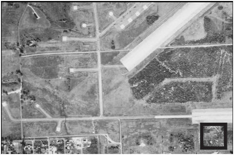
This is an aerial view of the southwest corner of Hancock Airport taken on October 15, 1951. Hinsdale Road is running along the bottom of the picture at the left and Sand Road can be seen coming in from the left side of the picture a little below center.
|
|
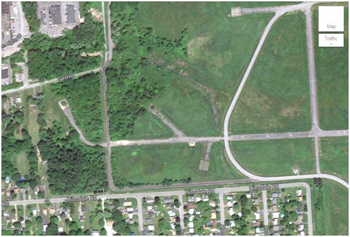
This is a picture from 2014 showing an enlarged version of the the same area shown in the lower left hand corner of the 1951 photo above. With the exception of an addition road on the airbase side and some more houses on Hinsdale Road, the area looks very much the same 63 years later.
|
|
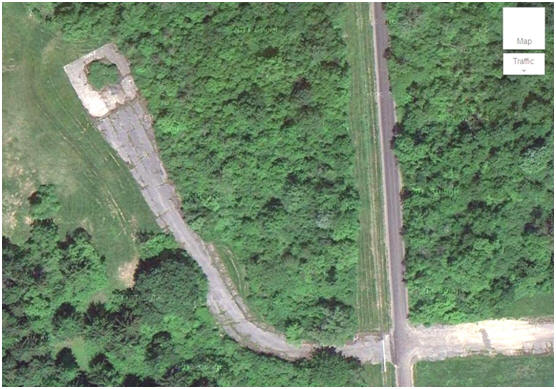
This is a close up of the far left pad seen in the 2013 picture. As the trees and underbrush have taken over the area since that time, it appears that these pads were hidden among the trees for security reasons. In the early 1940s, when these pads were in use, this was all open, former farm land. Even in the 1951 photo it can be seen that there was no growth of trees to hide the pads from view.
|