|
Old Brewerton Road |

|
Old Brewerton Road |
|
|
Introduction In front of the houses and businesses along the west side of Brewerton Road, from West Molloy Road to Garden City Drive, there appears to be a private road. On maps it is seldom labeled but the Google maps labeled it as Old Brewerton Road. What little has been written about the old road tends to link it with the construction of the Thruway in the late 1940s and early 1950s. That major highway sliced off the very southern portion of Mattydale, running east and west south of Young Avenue and north of Edgemere Road. That explanation turns out to be incorrect even though both construction projects took place in the same time frame.
The reason for the existence of Old Brewerton Road becomes apparent if one does a quick review of the changes in traffic flow through the Mattydale area of the years. The roads emanate from the village of Salina that became the First Ward of the City of Syracuse in 1846. At first there was an Indian trail that became the State Road (1812), also known as the Salt Road, that allowed the salt boilers of Salina to haul their products to Oswego where they could be shipped on the Great Lakes. This Salt Road, also know as LeMoyne St., proceeded north from what is now Washington Square (originally this was the first cemetery for the village of Salina) and traveled straight north, following what is now the southbound lane of Brewerton Road. In 1846, when the Cicero Plank Road was constructed, it left Salina village along Wolf Street and angled to the east, intersecting the Salt Road where Molloy Road now intersects Brewerton Road. The reasons for not just "planking" the entire Salt Road are explained in a paper on this site. After the construction of the plank road not much changed in the traffic flow through the area until the coming of the trolley around the turn of the century.
And Then Came the Trolleys Extending the trolley line to the many resorts on Oneida Lake was the dream of many business men in Syracuse. Providing transportation for the masses was the message they used to sell the idea to the public and to get the needed franchises from the different areas through which the trolley lines would pass. The trolley lines paralleled the Cicero Plank Road in passing through what would become Mattydale. As it neared Pitcher Hill the trolley lines veered off to the east and continued on to Centerville (North Syracuse), still parallel to the plank road but separated. After passing Centerville the real reason for the trolley line became apparent as it took direct aim at Lower South Bay, the location of a hotel for sportsmen (the present location of Lake Shore Golf Club). By the time the trolley line reached South Bay it was quite a bit east of the village of Cicero. This was a point of contention for the citizens of Cicero for many years.
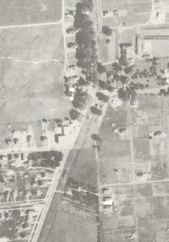
As the trolley lines passed through Mattydale, traffic on LeMoyne St., which was to the east of the trolley lines, was forced to cross the trolley lines to reach the plank road. By 1926 the situation was as depicted in the aerial photo shown below. LeMoyne St. is shown entering from the bottom in the center of the picture. Extending this initial portion of LeMoyne shows that it would intersect the plank road at Molloy Road, however it takes an eastward turn and parallels the plank road until LeMoyne reaches Molloy Road. North of Molloy, LeMoyne became Mattydale Drive, changed the name to Hinsdale Drive and then stops at Sand Road.
The End of The Cicero Plank Road The Cicero Plank road was bought from its owners by Onondaga County in 1913 and was the last toll road to be shut down in the county. There were two lanes on the plank road. The southbound lane, on the west side, was the actual plank road. On the east side was a dirt "turn off" for north bound traffic that was expected to yield to southbound traffic, that had the right of way. When the plank road was replaced by a modern road there were still two lanes but both were now paved. Running parallel and east of the trolley racks in Mattydale, from Molloy Road to Sand Road, was a road that had two portions. The southern portion fronted Frank Matty's farm and was called Mattydale Drive while the northern portion fronted Perry Hinsdell's old farm and was called Hinsdale Drive. These roads were intended for local traffic at that time.
Buses Replace the Trolleys On Monday night, January 11, 1932, the last trolley ran through Mattydale and they were replaced by buses the next day. Eventually Mattydale and Hinsdale Drives were widened and were connected with LeMoyne Ave. Now Mattydale had two main roads running through the little hamlet and at some point the western road became the southbound lanes of Brewerton Road and the eastern road became the northbound lanes of Brewerton Road. This presented traffic logistics problems because these roads were two way roads south of Mattydale and were one way roads while passing through Mattydale. With the arrival of World War II the solution to this traffic problem was postponed until later. After the war, retuning vets created a huge housing problem which demanded an immediate solution. By the late 1940s Mattydale's little traffic problem had worked its way back to the top of the list, helped in part by the increased traffic from the returning vets and their growing family moving into the suburbs.
|
|
|
1926 aerial photo of the southern portion of Mattydale with Brewerton Road (west) and LeMoyne Ave (east) entering from the bottom.
|
|
|
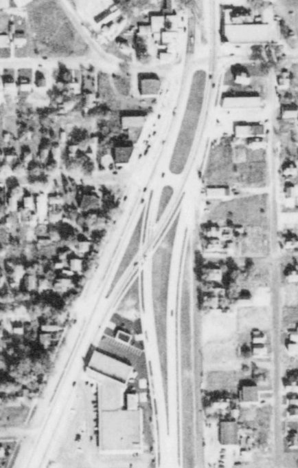
The solution to the Mattydale traffic problem is shown in the map below. In answer to the question, Why? The cross over could have been executed using the older roads but the closeness of those roads to private residences and the expected increase of traffic flow required the roads to be moved in the interest of safety.
|
|
|
The solution of Mattydale's traffic flow problem is shown in the October 1951 aerial photo. |
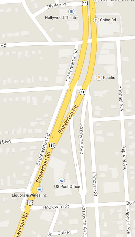
This 2014 Google map shows Mattydale's traffic solution displays very little change over that intervening 63 years. Off to the west can be seen Old Brewerton Road.
|
|
Another Old Road On the east side of this complex intersection is another old remnant. This is LeMoyne Street which was the original location of the Salt Road. This road became a residential street, while on the west side of the complex the old road picked up an "Old" prefix which preserved a link to its past existence as part of the old Cicero Plank Road. Perhaps LeMoyne Street should be renamed the Old Salt Road.
|
|