|
Roads and Other Things |
|
Old, New, Gone & Sometimes Confusing |

|
Roads and Other Things |
|
Clay Road = Clay Corners Road = Morgan Road
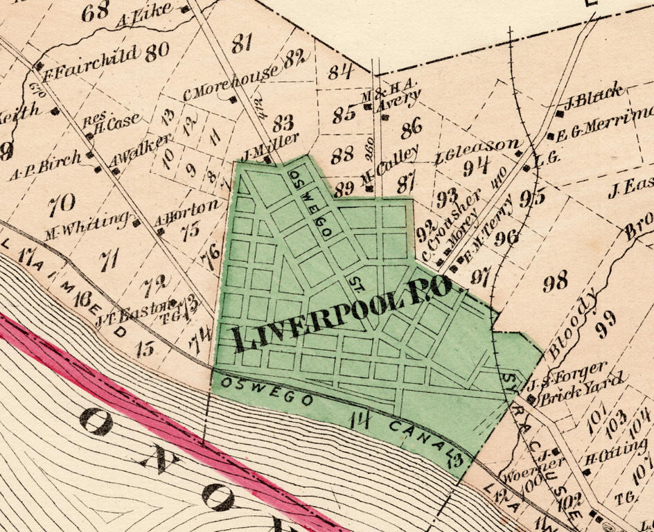
There are five major roads that lead in and out of the Village of Liverpool, as shown on this 1874 map. Although they have been improved over the years all five roads still exist. Starting from the left and proceeding to the right, the first road is Cold Springs Road or route 370. Second is Route 57 which goes to Fulton and on to Oswego. Third is Morgan Road and this road goes to Clay Corners (now Euclid, on route 31) and continues on to Phoenix. The fourth is Vine Street which then became Bear Road as it crossed 7th North Street. The fifth road enters from the far right and was, at the time of this map, the Liverpool Plank Road, now it is the old Liverpool Road. The confusion arises not only from name changes, which are at least officially recorded, but from persons naming the road in conversation or in newspaper articles according to the locations they pass through. From outside the village, all five of these roads could be referred to as the "Liverpool" road because they all lead to that destination.
|
|
Fay Road = West Taft Road
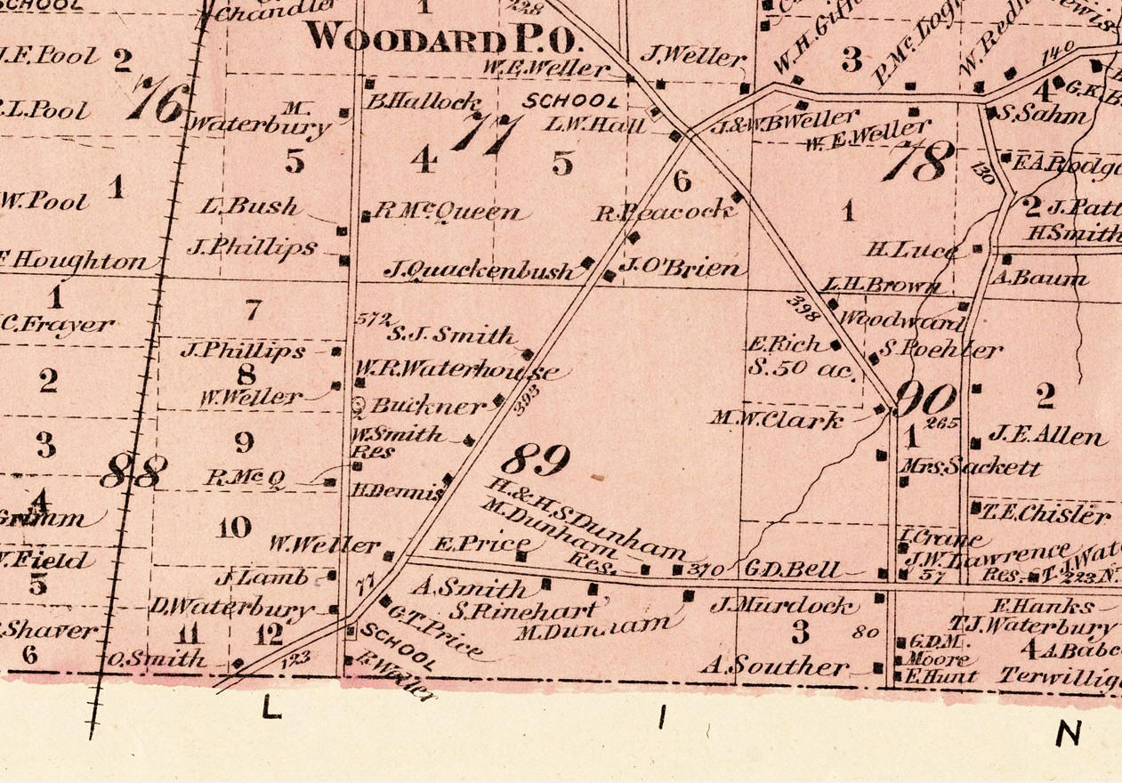
This is a 1874 map of the Town of Clay. 7th North Street is the north-south road passing through the "O" in Woodard. Its intersection with Bear Road is at the bottom of the map to the upper right of the letter "L" in Salina. Dunham Road is the long horizontal road which intersected Bear Road just northeast of the Bear Road - 7th North Street intersection. There are at least two persons named Dunham whose property is shown along this road. This would have been a sufficient reason for calling it Dunham Road.
|
|
Buckley Road
This is a section of the 1947 USGS map of the Syracuse Quadrangle. Buckley Road is the vertical road on the left hand side of the map. Buckley Road heads south into a region along the north shore of Onondaga Lake that was once called Greenpoint. Over the years several roads that led to that area were referred to as "Greenpoint Road." As far as can be determined, until just recently there never was a road officially named Greenpoint Road.
|
|
Gone - Part of Hancock International Airport
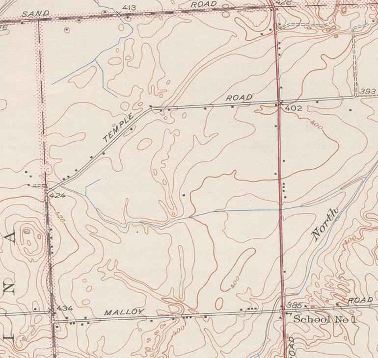
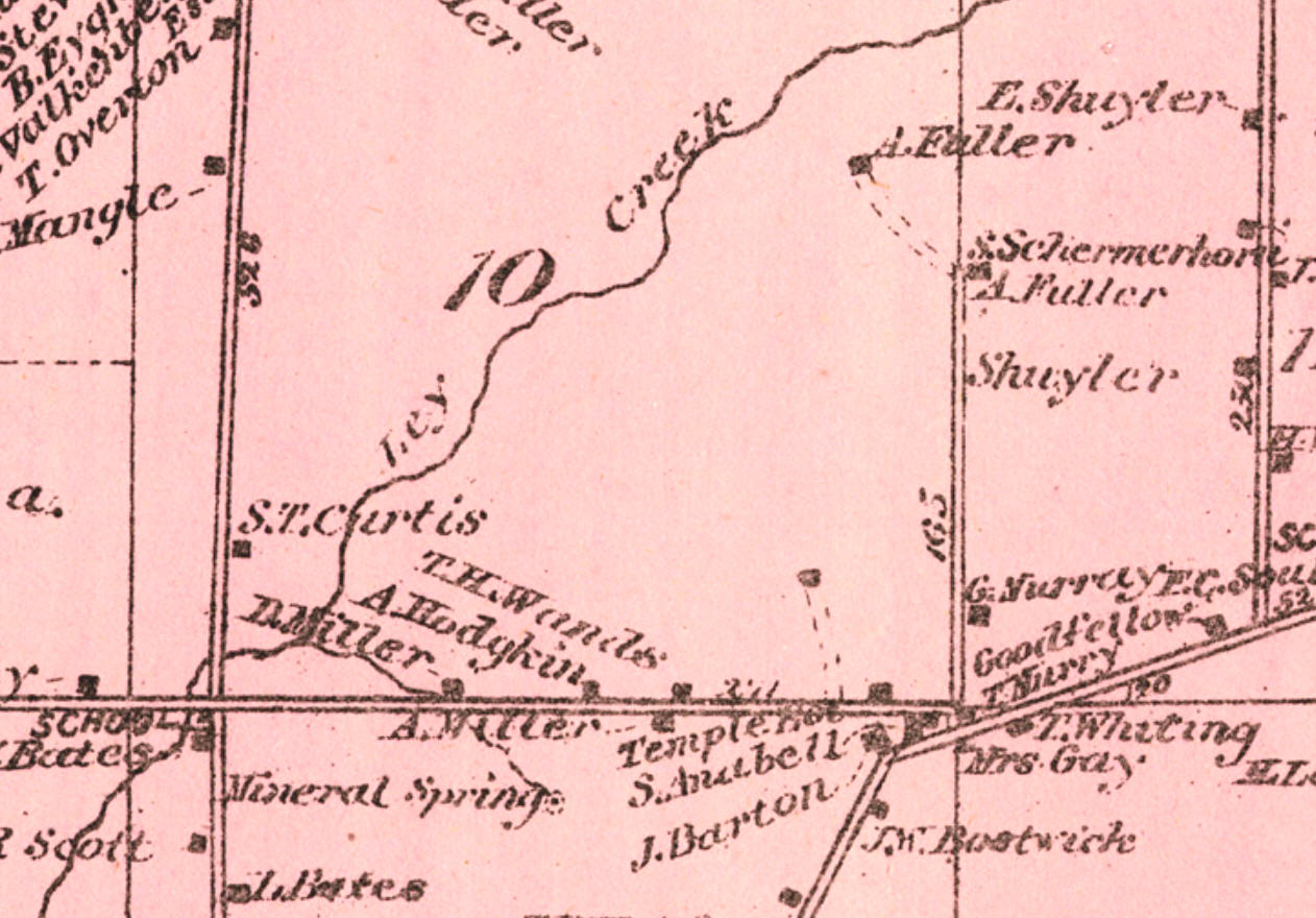
This is a portion of the 1943 USGS map of the Syracuse East Quadrangle (Surveyed 1938). This road is shown on the 1860 and 1874 Onondaga County maps and the 1898 USGS map of the same area. However, the 1898 map is the only one that showed the road labeled with a name. The authority of these government maps makes it difficult to ignore the assignment of Temple Road to this particular road. The information for these maps was gather carefully and not written down in a notepad by a young reporter during a disaster, who was trying to beat a deadline.
In the earlier maps there weren't any persons named Temple living in the vicinity of the road named Temple on the 1893 USGS map. However the 1874 map above shows a "Temple Res" just west of a point where East Molloy Road meets Kinne Road, just above the Collamer Road that is angling up from the bottom of the map. The 1900 census for the Town of DeWitt showed three Temple families living along this same section of what is now East Molloy, between Thompson Road and the short end of Kinne Road. That would provide more than enough reason for this section of East Molloy Road to be called Temple Road. However, that makes the presence of a Temple Road in the northwest corner of DeWitt Lot 9 even more confusing, since none of the Temples had any interests in that area..
|
|
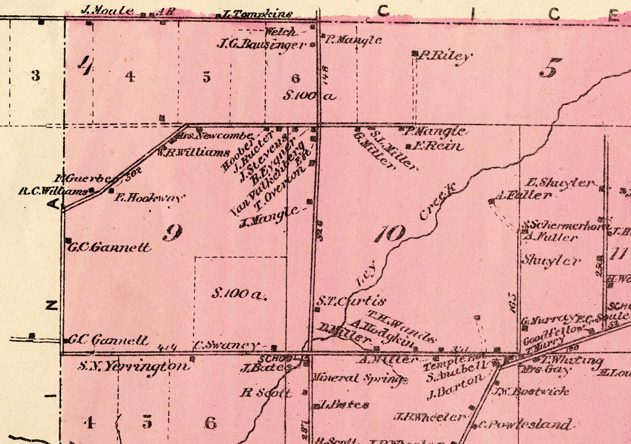
East Molloy Road
1874 Town of DeWitt, northeast corner. Starting in 1847 Warren Gannett had a dairy farm in the southeast portion of DeWitt lot 9. After his death in the late 1860s, his son George Gannett took over the farm.
|
|
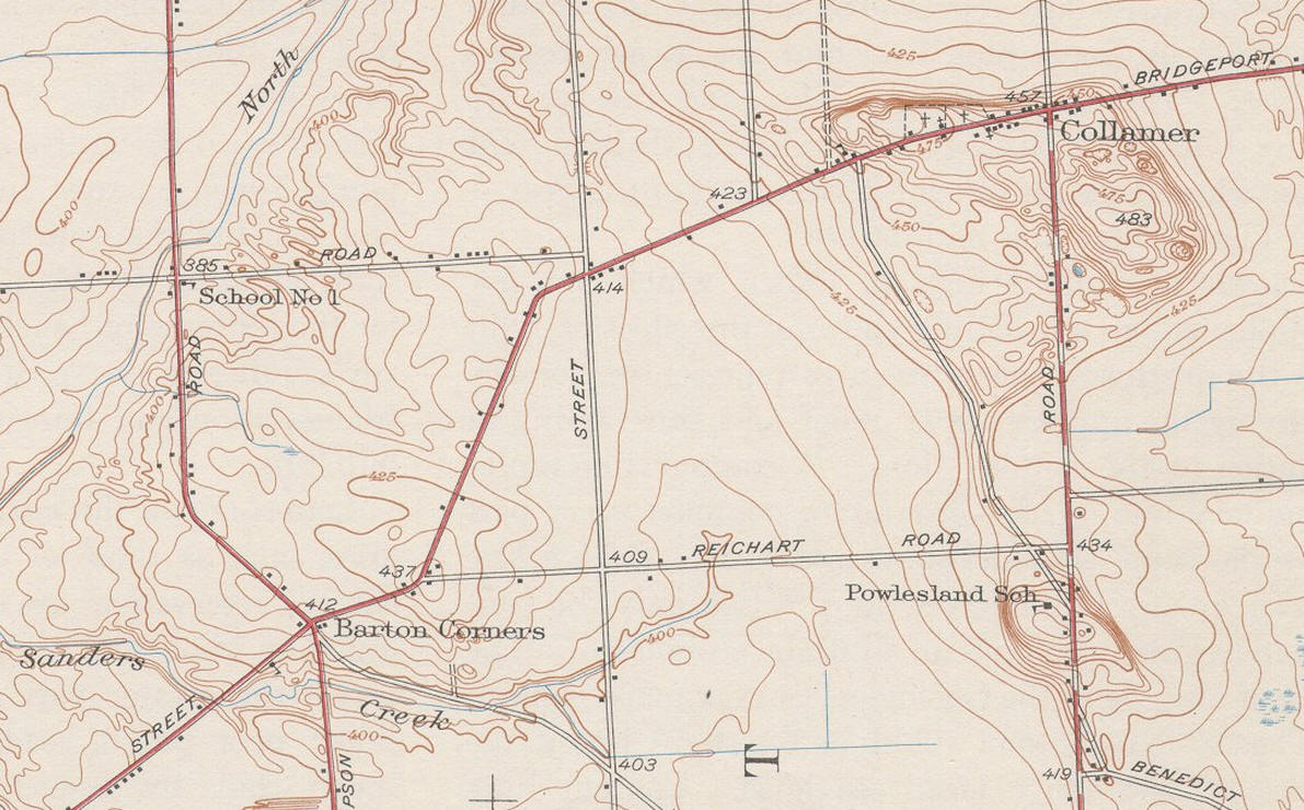
Bridgeport Plank Road = Collamer State Road = Old Collamer Road
1898 USGS map - Town of DeWitt
Barton Corners, which was located at the intersection of Thompson Road and the Bridgeport Plank Road, is now the site of the GM Traffic circle and the old Bridgeport Road is now called Old Court St. or the Old Collamer Road.
|
|
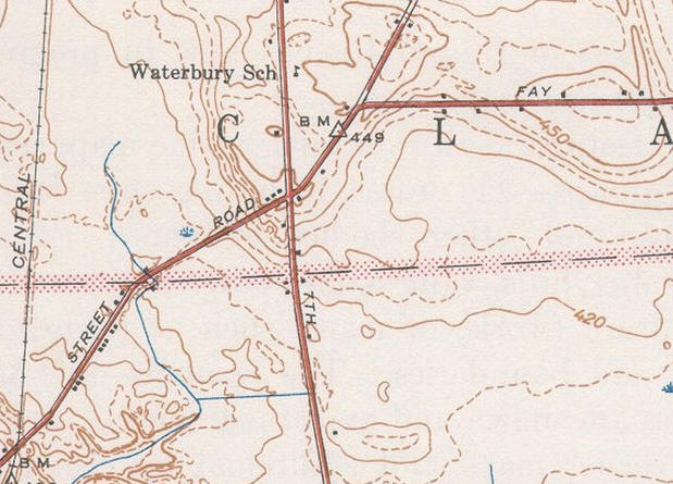
Waterbury School and 7th North Street
This is a 1947 USGS map showing the Waterbury school on the east side of 7th North Street, which is running north and south through the center of the map. Today it is called Henry Clay Blvd, to the north and also Henry Clay Blvd., to the south, to Hopkins Road where it becomes Electronics Parkway. Dunham Road, running east and west, entering from the right and intersection Bear Road, was called Fay Road at the time the map was published. The road running diagonally from the southwest to the north east is called Vine Street from the 7th North Street intersection into the Village of Liverpool. East of the intersection the northeast portion is called Bear Road. The horizontal dashed line passing through the center of the map is the boundary between the Town of Clay on the north and the Town of Salina on the south side.
This is a 1874 map of the same area as shown in the 1947 map. 7th North Street is the north-south road passing through the "O" in Woodard. Its intersection with Bear Road is at the bottom of the map to the upper right of the letter "L" in Salina. The old school was in the southeast corner of this intersection. Across the roads, in the northwest corner was the farm of D. Waterbury. Further north, on the west side of the road is M. Waterbury. One of these persons is probably the Waterbury who the brick schoolhouse was named after. The area was officially known as the Waterbury School District.
|
