Our Trip to Ireland - August 2006
Counties: Clare, Galway, Mayo, Tipperary, Waterford

| e |
| Day 1 & 2 - Austin to Ennis, Co. Clare Franciscan Friary,, Quin Abbey |
| Day 3 - Cliffs of Mohr, The Burren, Kinvarra |
| Day 4 - Galway, Kylemore Abbey |
| Day 5 - Co. Mayo, Galway & Clare Clonbur, Cong, Ashford Castle, Athenry, Feakle, Scarriff |
| Day 6 - Co. Clare & Co. Tipperary Killaloe, Ballina, Upperchurch |
| Day 7 - Co. Tipp., Thurles, Moyaliff, Ballycahill, Farney Castle, Ballynahow Castle |
| Day 8 - Co. Tipp., Local Studies Center, Thurles, on the road to Cahir and Cahir Castle |
| Day 9 - Co. Tipp., Currigeen Castle (B&B), Clonmel, Co. Waterford, Kilmanahan, Cashel - Brú Ború Center |
| Day 10 - Co. Limerick, Adare Village, Rathkeale - Castle Matrix, Ashkeaton - Ashkeaton Castle, on to Ennis |
 |
|
Moyaliff Cemetery in the parish of Moyaliff south of Upperchurch. To see more Moyaliff pictures click here. |
 |
|
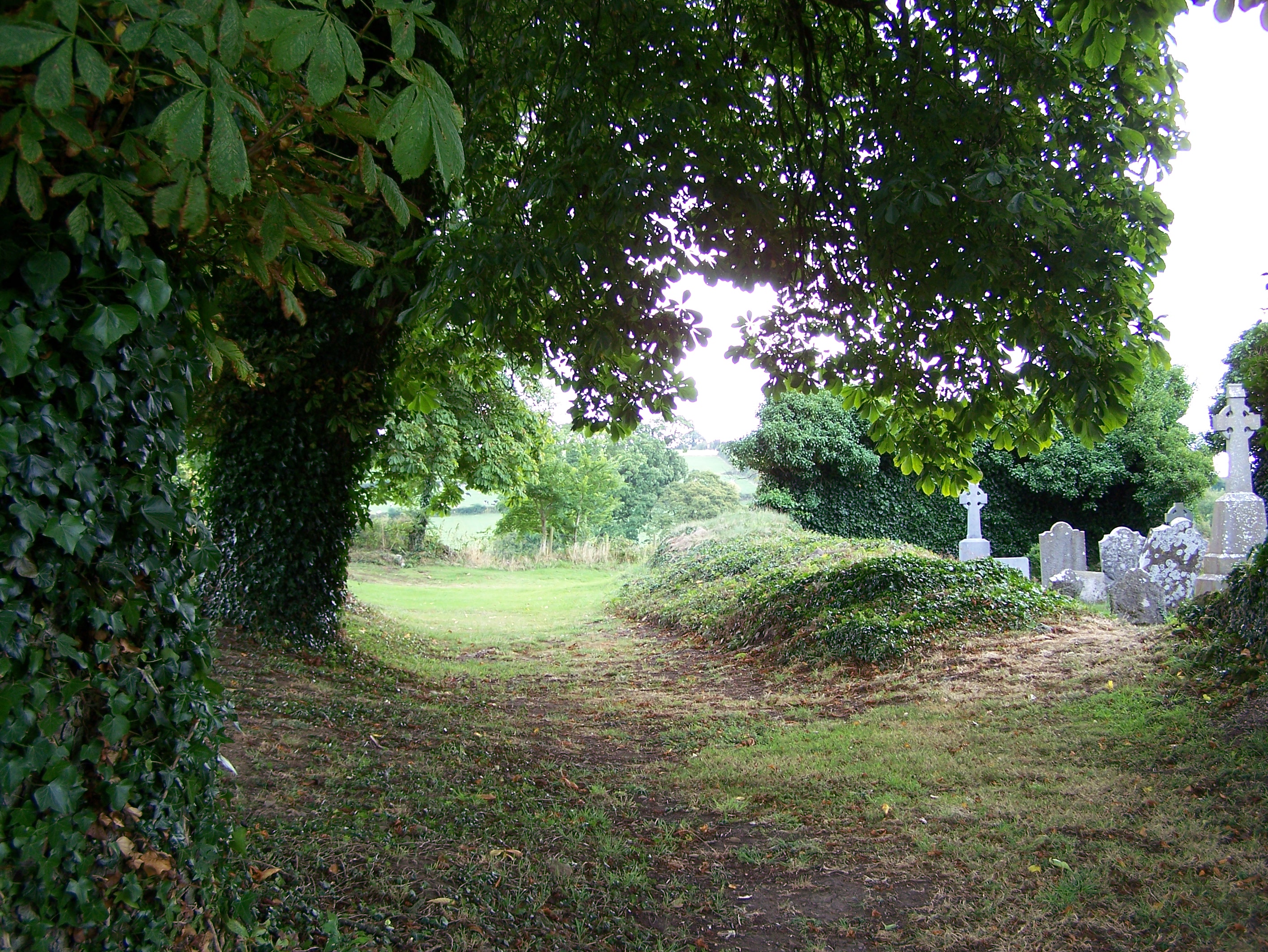
The ancient chestnut trees shadow the earthen mount over one of the fallen walls of Moyaliff Chapel. |
|
|
|
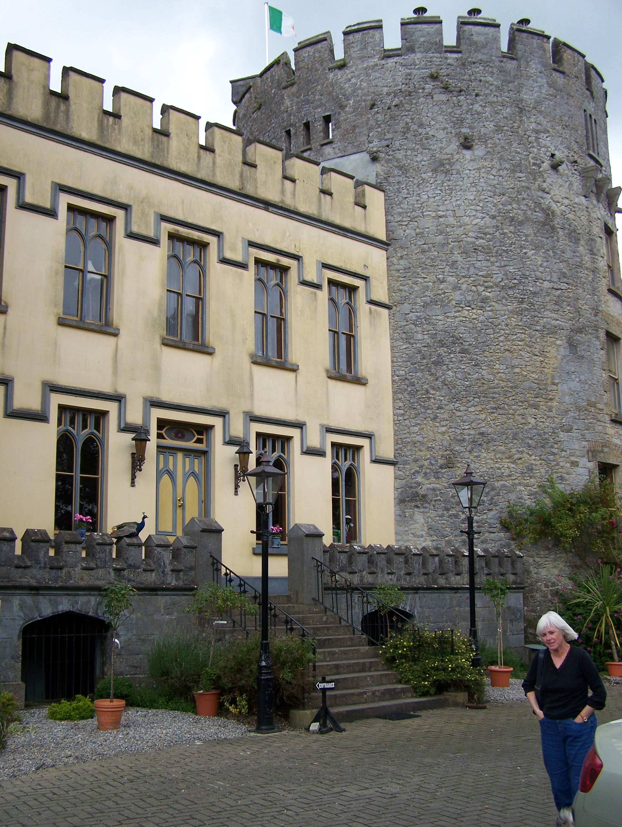
Farney Castle, Co. Tipperary |
 |
|
The many harps of Farney Castle |
 |
|
Ballycahill Cemetery. For many more pictures of this cemetery click here. |
 |
| Ballycahill Cemetery. For many more pictures of this cemetery click here. |
 |
| Ballynahow Castle. This was a 16th century Purcell Castle |
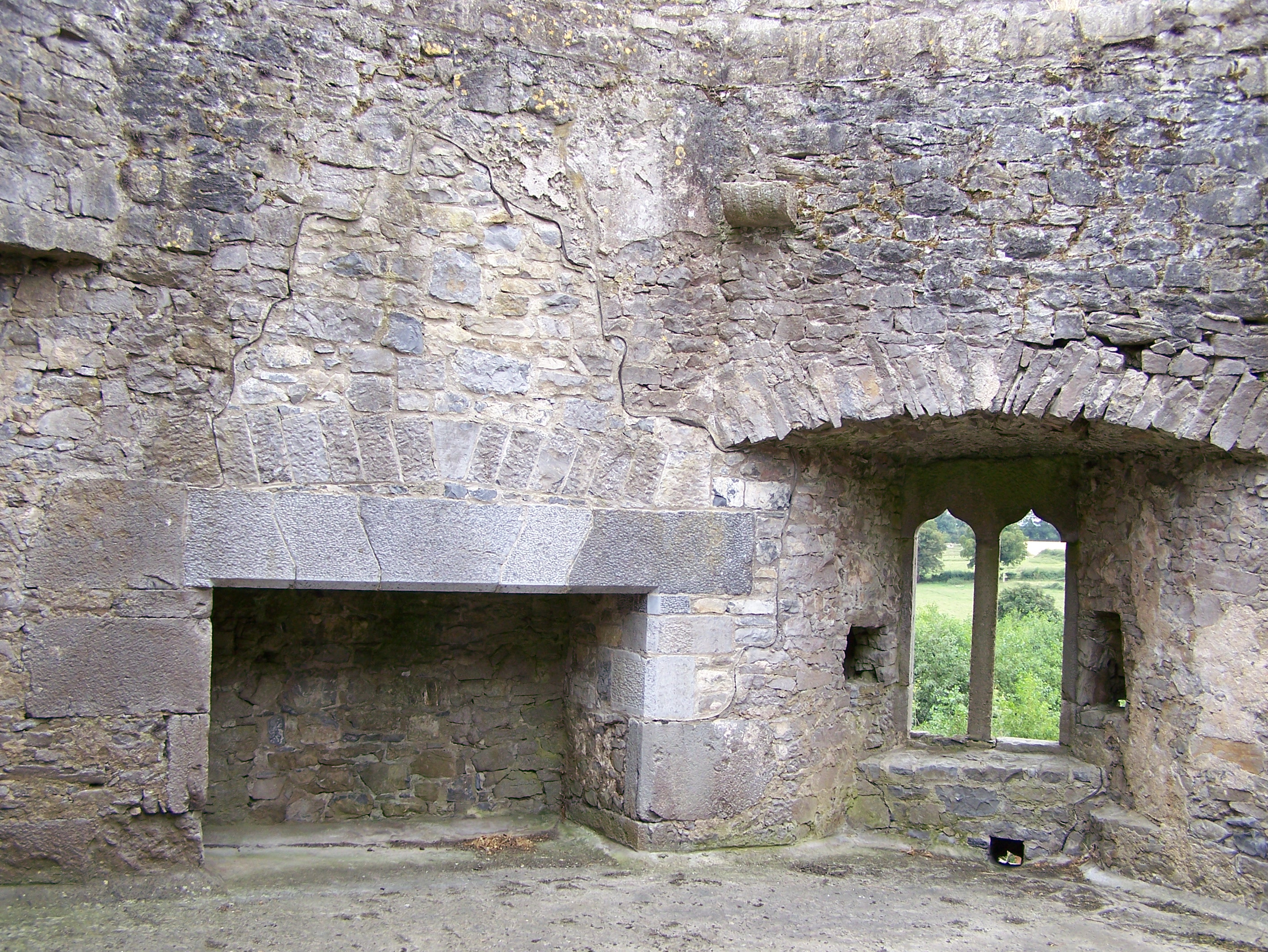 |
| Interior view of one of the upper levels of Ballynahow Castle. |
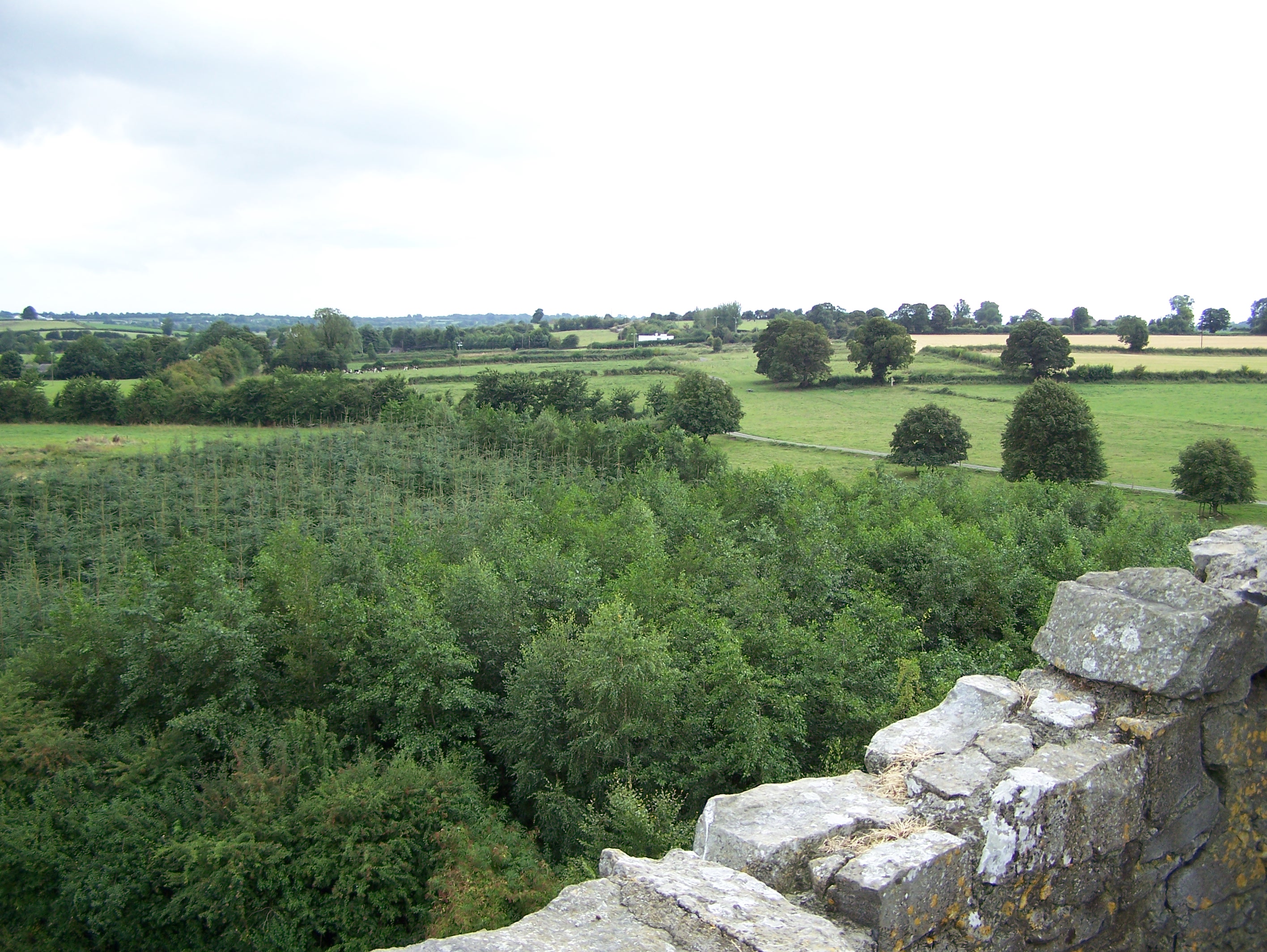 |
| View of the Co. Tipperary countryside from the top of Ballynahow Castle. |
 |
| Templebeg Cemetery. For more pictures of Templebeg Cemtery click here. |
 |
| Noël makes a friend at Cuillen House, Thurles |
Copyright © 2006 - Michael F. McGraw
|
Upperchurch Connections |
What's New? |
|||
|
|
||||
 |
||||
|
||||
Day 7 – Tuesday Aug. 22, 2006
After breakfast at the Cuillen House B&B we stopped to fill up the car with diesel fuel (1.24 Euros/liter – in Ireland it was cheaper than regular gas) on the way into the town of Thurles. At the edge of Thurles we headed west looking for R503 (Anglesley Road) but missed the turn and wound up in Borrisoleigh. I knew something was wrong when signs for Inch House started showing up on my left (south) when Inch House should have been north of us. So we turned around in Borrisoleigh, retraced our path, found R503 and headed west to the Moyaliff turnoff just west of Ballycahill.
This was going to be “Cemetery Day” and our first stop was Moyaliffe Cemetery. The ruins of Moyaliff Church were shown on the Discovery Series, Ordnance Survey map. A previous attempt at visiting this cemetery, by relatives, some years ago, had met with failure due to the time of year and the muddy conditions of the field. A while back I had tripped over an Irish building permit filing on the Internet for the construction of an improved access road to the cemetery. So, I was hoping that the project had been approved and completed. Luck was with us – the Moyaliff Cemetery now had a stone driveway that led all the way up to the cemetery. The plaque at the entrance of the cemetery indicated that the improved road had just opened in Dec 2005.
The graves were located both inside and around the east and south sides of the ancient chapel. This chapel was in ruins at the time of the Ordnance Survey maps that were made in the early 1840s. One of the McGrath graves inside the chapel listed the date of death as 1792, indicating that the church was in ruins as of that date. Without the aid of extensive research I would venture a guess that the chapel predates the Penal Era thus pushing its construction at least into the 17th century. Only a portion of the walls on the east, west and south sides were left standing. The west end appears to be full height while the north wall is essentially gone and appears as a low mound that is easily crossed on foot. There were four McGrath graves side by side inside the ruins near the west end. The Banan stone was there, but not the other McGrath graves that had been reported by the Nenagh Heritage Center. I’m sure they had been working from an older list that included stones that had since fallen over or had become unreadable. However, it did not appear that the missing McGraths could have been located close to these four graves for lack of room. Perhaps indicating they were part of another family group.
Many small rocks had wooden crosses or just sticks placed into the ground near them. It appeared that some graves were marked with just these ordinary rocks. There weren’t any indications that these were the remnants of crumbling gravestones that had been located there at one time but were just simply good-sized rocks. Perhaps they had been selected because of a distinctive shape by grieving family members too poor to afford real gravestones for their loved ones. The elevated location of Moyaliff and its association with an ancient church would seem to make it the most desirable location for a burial – the preferred location. Upon leaving Moyaliff we continued west toward the townlands of Glebe and Drumbane that were just down the road. We couldn’t easily discern the Glebe area, which was small to begin with, but there was a church in Drumbane so we traveled on a little further. However, there were only two recent graves in the front of the church property and were the final resting places of clergy that had been associated with the church. The 1840 Ordnance Survey map indicated a graveyard had not been there in the mid 19th century. All these areas are very close together. Drumbane, Drumdiha and Moyaliff are within easy walking distance of each other.
We backtracked up the road that had led us to the Moyaliff Cemetery looking for Farney Castle that was located just east of Moyaliff Hill. This was an old Armstrong holding. We got a tour of the castle from the present owner, Cyril Cullen and bought a small harp figurine that Cyril had designed and made. There was a very friendly sheepdog, named Oscar, who posed for a picture with Noël. |
Leaving Farney Castle we went back up R503 and checked out Ballycahill Cemetery just as it was starting to rain. This cemetery was located right on a “main” road (R503) so access was no problem. There was one McGrath grave that I found and the ruined walls of another ancient church. As the rain picked up I shot a few more pictures and then we walked back to the Ballycahill pub for some drinks.
Once back on the road we went looking for Ballynahow Castle (Tower House) that Noël had seen in the distance, north of R503, as we were heading into Thurles the day before. This was a 16th century Purcell Castle and was presently located on private property. There was a cottage and some out buildings located near the base of the tower but the whole place looked as though it had been deserted for some time. There was some construction work in process toward the back of the property (cinderblock structure) and the workman said it was OK to go up into the tower.
This was a round tower with five floors plus an attic and a defensive walkway. Two floors were stone arch supported and so had survived the years. The others had been constructed of wood and of them nothing remained except the stone corbels that had once supported them. There were many defensive features visible in the ground floor and 2nd floor levels. There were two fireplaces and TWO garderrobes. A nice murder hole survived over the main entrance with arrow slits all around. The state had taken over custody of the structure in 1930 and added some repairs and a reinforcement rod across the diameter of the 5th floor for structural support.
After Ballynahow we went west on R503 looking for Templebeg Cemetery – our last for the day. A little past Ballycahill we headed north on a narrow unmarked road and about 1 km down the road I saw something out of the corner of my eye as we passed an even narrower road on my right. Traveling on these unmarked roads is only possible with a good map (Discovery Series Ordnance Survey map) and a careful count of “crosses” and “T’s and the use of hills and streams for landmarks”
Turning around – which wasn’t easy on those narrow roads- we went back to the turn off. This was indeed the Templemichael (Templebeg) Cemetery and so we went a little further up this narrow road looking for a place to park or at least a place to pull over. Near the end of the road there was a new modern house being built – there seemed to be large, expensive houses going up everywhere we went in Ireland. We turned around and came back down the road and stopped in front of the cemetery entrance. It was obvious we couldn’t drive any closer to the cemetery and the only place available to leave the car was the small entrance to the cemetery itself. I pulled the car over to the left as far as I could into the small entrance to the cemetery but it was still half in the road. Good enough – and over the fields we went - always looking down because these were cow pastures. Templebeg Cemetery was located across a cow pasture but was marked with a sign and was still an active cemetery. There were the ruins of an ancient chapel in this cemetery also – the third one today. And as was the case in the others, there were graves both inside and outside the crumbling walls of the ruins. We shot a few pictures and quickly checked out the inscriptions on the stones for familiar names. There weren’t any Magrath graves that we could locate even though the Nenagh Heritage group had one or more on their list.
We headed back towards Thurles and scouted out some possible restaurants for dinner. We made several obligatory checks of the local stores for Terry’s Twilight Mints and of course we never found any. We ate at the Cusack Bar attached to the famous Hayes Hotel on the main town square, where the GAA (Gaelic Athletic Association) was founded by Michael Cusack back on November 1, 1884.
|
|||