| Mattydale Mysteries |
|
Missing, Misplaced or Just Mysterious |

|
Mattydale Mysteries |
|
Introduction As I have tried to uncover and re-discover the history of Mattydale it has been possible in some cases to figure out why events happened as they did or why things look like they do or why buildings and streets are located where they are - but not always. Unanswered questions and mysteries still remain. Here's a chance for some audience participation if anyone wants to get in on this game and help find some of the missing pieces.
|
|
|
|
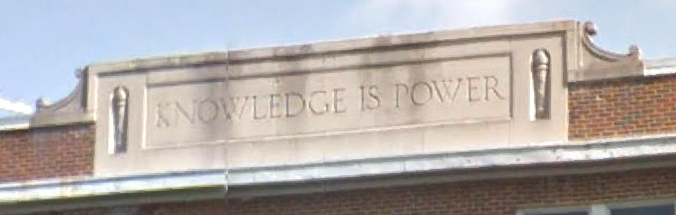
“Knowledge Is Power” Frank Matty fought for this phrase to be engraved on the front of the new school, according to him in one of his birthday interviews (see page 17).
Frank Matty - from a newspaper interview on the occasion of his 82nd birthday. "And you have to play politics every day in the year and fight to win every night." It took me six weeks to get upon that cornice of our school the words I wanted there: 'Knowledge is power.' "
"But I waited and fought and those words are the words up there. What better expresses the whole idea of what it's all about, and what it's all for, than those simple words. Some wanted six or seven words; I don't know why!
" 'Knowledge is power!' That hits it; It's knowing what it's about and how to do it."
"Frank Matty, Always Politician, Still Follows 50-Year Philosophy Of 'To the Victor Belong the Spoils'," The Syracuse Herald, Syracuse, NY, Sunday, November 20, 1932
No other mention of this inscription, or the process by which it came to be selected, or the other possible candidate inscriptions, has been found. |
|
Mattydale VFD – Why Are The Trucks Yellow? Even the oldest firemen don’t have an answer.
Here’s a possibility: For years the Mattydale VFD kept their equipment in the north end of Frank Matty’s double barn. At various times the barn might have also been home to bees, perhaps yellow jackets. From there the firemen might have taken on the name “Yellow Jackets” for their nickname. When they upgraded their early equipment and needed to pick a color they might have thought of their cohabitating bees and picked yellow for the color. |
|
Northern Lights Ornamental Bushes The Northern Lights Shopping Center officially opened on Wednesday, November 16, 1955. At that time, or shortly thereafter, some small bushes were planted on the slope located on the north side of Sand Road on the southern edge of the new shopping center. The bushes were planted so that they spelled out the name "Northern Lights." They were clearly visible for years to everyone heading south on Brewerton Road.
A 1966-07-01 aerial photo of the area shows that the bushes were gone by that time. An extension of the Howard Johnson's Motel was built on that slope on the north side of Sand Road.
So far, NO pictures of those bushes have been found. |
|
What Became Of The Original Hand Held School Bell? The bell was used in the old one room school house, prior to 1923, to call the children to school. In 1923, when the new brick school house was completed, everyone moved to the new building and took the bell with them. In 1953 a dedication was held for the new gym and cafeteria. "Originally, Mattydale School was a one-room school and the hand bell which called the children to school now reposes in the school vault, packed in a box lined with velvet." [1953-10-29]
The bell was stored in the new school and it was in the principal’s (Roger Carter) office safe in the 1970s. In the late 1970s the transfer of grades from Riordan, across Brewerton Road to Roxboro Road Elementary School, was begun and by the early 1980s Riordan School was closed down. No one at the District office, nor a life-long resident, and former member of the now defunct Plank Road Historical Society, had any knowledge of the Mattydale school bell (1-14-14).
|
|
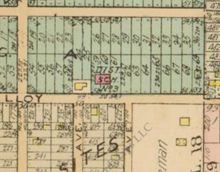
Where Was The Original One Room School House Moved? NEW- 08-11-22 - The Old School House has been found - LINK It became a residence on one of the nearby streets, according to Gertrude Duplessis’ History of Mattydale. “This early school was moved to Matty Ave. in 1922 and is occupied as a private dwelling,” p. 6.
In 1923 Matty Ave was only two blocks long, it ended where it butted up against the Wright farm. If it had been relocated in 1922, the old school house would have to be somewhere in those two blocks. However, on a 1924 map (shown above) the old school house (yellow) was still in place prior to the wing extensions being added to the original brick building (pink).
|
|
Why Is There A Roxboro Road? On the west side of Brewerton Road all the residential streets come out to the main road, all except Leonard Street. This street would have been a dead end on its eastern extremity had it not been for Roxboro Road. Before Kirsch turned the southern part of his farm into a residential development in 1927, three of his children had built identical houses along the western side of Brewerton Road. These effectively blocked Leonard Street from making a direct connection to Brewerton Road. This would have forced residents in the 100 block of Leonard to backtrack to Belmont Street and then over to Kirsch or West Molloy to get out of the development. Hence Roxboro Road came into existence. This is one possibility as to why Roxboro Road was constructed, but where did they get that name?
|
|
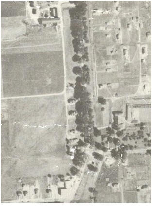
This is a portion of a 1926 aerial photo showing the Kirsch property along the west side of Brewerton Road in the year before the residential development began. Down the center of the photo are the stately elms that once formed a canopy over the Cicero Plank Road now Brewerton Road in this photo. Along a parallel path just to the east of Brewerton Road was the trolley line. On the west side of Brewerton Road, and parallel to it, is a private road running from the Kirsch barns at the top of the photo to the three Kirsch houses below. The horizontal road extending west from this private road never became a road in the Kirsch development. It was located in an area between what would the following year become Kirsch Drive, to the north, and Leonard Street, to the south.
|
|
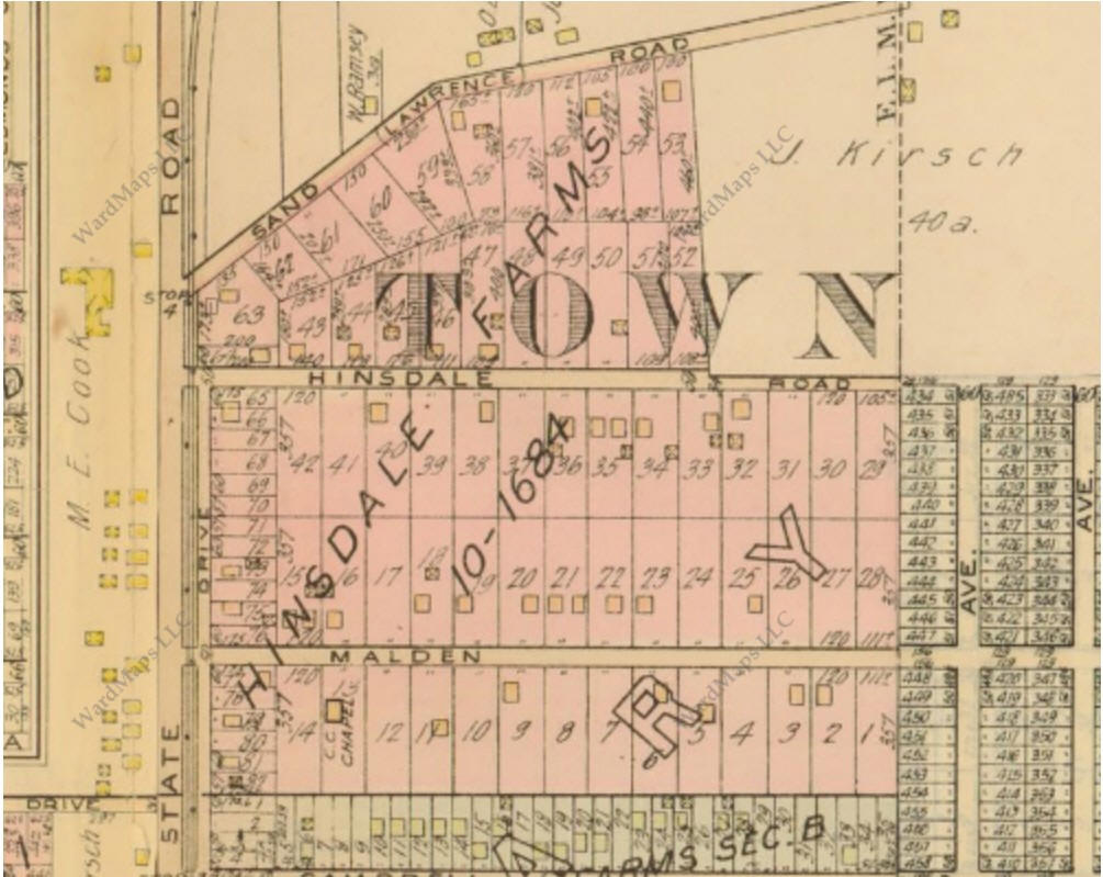
This map is from an atlas of maps of Syracuse and adjacent areas that was published in 1924 according to its internal documentation. However, the plans for the Kirsch tract were filed in the Onondaga County Clerk's Office in 1926 and revised in 1927, another mystery. The part of the development shaded pink never happened, it later became the Roxboro Road schools.
The light colored rectangle in the northeast corner is labeled "J(ohn) M(ichael) Kirsch," but that is actually the old Rose Lawn property of Benjamin Baum. Kirsch's house and farm buildings are in the block on the south side of Baum's former property and that area has been shown as being "subdivided" but it wasn't. The former Baum property was owned by Theodore Faatz and was the site of The Rural Inn roadhouse also known as Faatz's Hotel. In 1923 Faatz sold the property of Delphine A. Brown who, with her husband, owned the property until 1940.
|
|
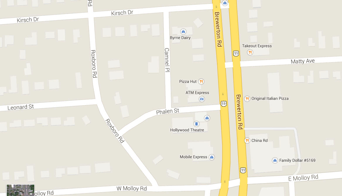
This is how the area is laid out today, but I don't know if I fully believe all the labels that appear on the different buildings. The part of the old private road running behind the Kirsch houses is now known as Camnel Place. On the 1924 map it was known as Driveway Place. The road connecting Roxboro with Brewerton is now known as Phelan Street, after the longtime bartender at Cam-Nel's. In 1924 it was known as Driveway Street. In the 1950s these were just unpaved, stone covered roads. We thought they were just pathways worn by the passage of cars over time and never knew that they had names. There were never any street signs to tip us off and in the winter the county didn't plow these roads, that was up to the business owners.
|
|
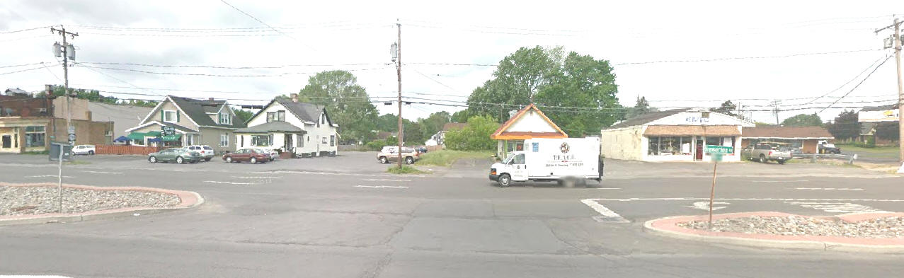
This is a Google Street View of the area near the old Kirsch houses, looking west from Brewerton Road, taken in May 2012. On the left are the two remaining Kirsch houses. The left house of the two has been operated as Cam-Nel's since the 1950s. If Leonard Street had been extended it would have come out between these two houses. To the right of the second house is a gap. The missing house was at one time the home of Leo Kirsch and it was located in the gap, behind the telephone pole. Behind the truck was the old Dairy Queen during the 1950s and 1960s. The building to the right of the Dairy Queen was Am & Em Fratamico's Superette in the 1950s, when my father could buy a week's groceries for a family of five for only $20. After that it became Wizard Electronics, in an era when it was still possible to repair radios and televisions.
|
|
The Roxboro Road Schools Are Not On Roxboro Road Roxboro Road Elementary School is on Bernard Street. When the school was built in the late 1950s Roxboro Road ended at Bernard Street and even though it has been extended in recent years to connect with the Orchard Estates Apartments, it runs along the east side of the schools while Bernard Street still runs in front of the schools. So why were the schools named after Roxboro Road, which itself doesn't seem to be named after anyone or anything in Mattydale?
|
|
Short Streets To Nowhere Holiday Drive - Hinsdale Farms development - One block long, extending south from Hinsdale Road. Holiday Drive was not part of the original development as seen in the 1924 map below.
Hinsdale Farm subdivision map in 1924
Niles Drive - Extending west from the southbound lane of Brewerton Road, between Malden Road and Hinsdale Road. In the 1940 census there was only one person living on this street, Murnes Cook. On a 1952 map, this short, one block long street was called Niles Drive. The property was originally part of Benjamin Baum's Spring Farm and later it had belonged to Murnes E. Cook. His wife's maiden name was Niles. The street was extended westward and renamed Endres Drive, in the late 1960s, when the apartments were built (ca. 1967) and it is now the entrance to the Orchard Estates Apartments. When the street was renamed and why it was named after Endres is not known. During the 1940s and 1950s there was an Edward Endres who was active in the affairs of the Mattydale Volunteer Fire Department and the Onondaga County Fire Association. In 1954 he was living at 204 Toas Ave, in Mattydale. After retirement he moved to California and passed away on November 7, 1973 in El Cajon, CA. [1973-11-10]
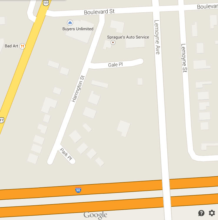
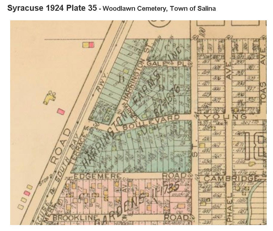
Gale Place and Park Place Both of these streets were part of the original Harrington Farm Tract that was opened for residential development in 1923. They were always short but originally they went somewhere. The origin of the names is not known. Gale Place connected Harrington Street with LeMoyne Street. Park Place originally connected Harrington Street with Boulevard (not the Boulevard Street that borders the south side of Mattydale Shopping Center). This Boulevard became Young Street after crossing LeMoyne Street. Both Gale and Park became short one block streets to nowhere as victims of progress. The Thruway took out all of Harrington Farms between Boulevard and Edgemere Road providing Park Place with a dead end in return. Gale Place was a victim of the expansion of LeMoyne Street that was moved west and widened to become LeMoyne Avenue. At that time access to and from Gale Place was terminated. It became a cul-de-sac, which sounds so much better than a dead end.
Gale Place and Park Place in 2014
Gale Place and Park Place in 1924
|
|
NOTES: [1953-10-29] - The Herald-Journal, Syracuse, NY, October 29, 1953. [1973-11-10] - "Endres," The Post Standard, Syracuse, NY, Saturday, November 10, 1973.
|

![[1953-10-29]](1953-10-29%20Mattydale%20School%20Dedication.jpg)
![[1973-11-10]](1973-11-10%20%20Edward%20J%20Endres%20Obit.jpg)